Log in
All resources
Create a design
Tools
7,171 Free Images of Atlas Map
joan blaeu
copper engraving print
british library
1667 maps
atlas maior, vol 10 (spain and africa) - joan blaeu, 1667 - bl 114.h(star).10
1660s maps of spain
david rumsey historical map collection
coats of arms on maps
atlas novus (blaeu)
maps of paris from the david rumsey historical map collection
atlas des anciens plans de paris by imprimerie nationale, 1900 from the david rumsey historical map collection
maps of paris from the david rumsey historical map collection
atlas des anciens plans de paris by imprimerie nationale, 1900 from the david rumsey historical map collection
maps of paris from the david rumsey historical map collection
atlas des anciens plans de paris by imprimerie nationale, 1900 from the david rumsey historical map collection
maps of paris from the david rumsey historical map collection
old maps of gelderland
old maps of zutphen
atlas des anciens plans de paris by imprimerie nationale, 1900 from the david rumsey historical map collection
maps of paris from the david rumsey historical map collection
atlas des anciens plans de paris by imprimerie nationale, 1900 from the david rumsey historical map collection
maps of paris from the david rumsey historical map collection
atlas des anciens plans de paris by imprimerie nationale, 1900 from the david rumsey historical map collection
maps of paris from the david rumsey historical map collection
maps from university of amsterdam special collections
atlas der neederlanden
old maps of duchy of troppau
maps of duchy of jagerndorf
old maps of the arctic
1645
maps by john cary
county of tyrol
maps by willem and johannes blaeu
atlas van loon
nieuwe en beknopte hand-atlas (1754)
old maps of the strait of gibraltar
old maps of shaanxi
animals on maps
maps of waterways in the netherlands
maps of nieuwe merwede
pacific ocean in art
ships on maps
continent
maps
maps by john cary
1799 maps
old maps of manchuria
general atlas (1773)
1801 maps of europe
maps by john cary
maps from university of amsterdam special collections
atlas der neederlanden
maps from university of amsterdam special collections
atlas der neederlanden
atlas maior, vol 5 (england) - joan blaeu, 1667 - bl 114.h(star).5
old county maps of caernarfonshire
atlas maior, vol 10 (spain and africa) - joan blaeu, 1667 - bl 114.h(star).10
1667 maps
old maps of the county of ravensberg
duchy of cleves
old maps of the polish-lithuanian commonwealth
17th-century maps of prussia
1740s maps of the netherlands
maps of borculo
maps of paris from the david rumsey historical map collection
romanticism
atlas maior, vol 6 (scotland and ireland) - joan blaeu, 1667 - bl 114.h(star).6
1667 maps
gemeente atlas van nederland - limburg
old maps of venlo
historisk atlas (stockholm, norstedt & söner, 1880)
maps of the history of scandinavia
atlas van der hagen (volume 4)
people with animals in art
maps of the county of flanders
county of zeeland
saint basil's cathedral in art
red square in art
maps by thomas kitchin
andrew dury
atlas maior, vol 4 (netherlands) - joan blaeu, 1667 - bl 114.h(star).4
1667 maps
1660s maps of spain
1667 maps
atlas maior, vol 11 (asia) - joan blaeu, 1667 - bl 114.h(star).11
1667 maps
gemeente atlas van nederland - north holland
maps of aalsmeer
maps of brazil by hendrik hondius
old maps of bahia
maps by willem and johannes blaeu
novus atlas blaeu
1660s maps of spain
1667 maps
1660s maps of spain
1667 maps
atlas maior, vol 10 (spain and africa) - joan blaeu, 1667 - bl 114.h(star).10
1667 maps of europe
general atlas (1773)
old maps of sakhalin
maps from university of amsterdam special collections
atlas der neederlanden
atlas maior, vol 2 (sweden, russia, poland, eastern europe, and greece) - joan blaeu, 1667 - bl 114.h(star).2
17th-century maps of estonia
old maps of guernsey
old maps of jersey
maps of districts of lower saxony
steinfurt in the 1640s
maps with cartouches
old maps of fujian
maps of ven (oresund)
old maps of skåne
maps of sterrenburg (utrecht)
atlas van loon
old maps of delfzijl
atlas van loon
maps of rotterdam by berckenrode
atlas van loon
old maps of delhi
catalan atlas
atlas des anciens plans de paris by imprimerie nationale, 1900 from the david rumsey historical map collection
maps of paris from the david rumsey historical map collection
atlas des anciens plans de paris by imprimerie nationale, 1900 from the david rumsey historical map collection
maps of paris from the david rumsey historical map collection
atlas maior, vol 2 (sweden, russia, poland, eastern europe, and greece) - joan blaeu, 1667 - bl 114.h(star).2
1667 maps of russia
1375 maps of europe
catalan atlas
atlas maior, vol 5 (england) - joan blaeu, 1667 - bl 114.h(star).5
old county maps of bedfordshire
atlas maior, vol 5 (england) - joan blaeu, 1667 - bl 114.h(star).5
old county maps of worcestershire
old maps of groningen (province)
lordship of groningen
maps from university of amsterdam special collections
atlas der neederlanden
atlas maior, vol 5 (england) - joan blaeu, 1667 - bl 114.h(star).5
old county maps of montgomeryshire
atlas maior, vol 5 (england) - joan blaeu, 1667 - bl 114.h(star).5
old county maps of denbighshire
engravings of buildings
maps by pieter mortier
petit atlas pittoresque des 48 quartiers de la ville de paris, bhvp
proletarian literature
17th-century maps of bohemia
1645 maps of austria
17th-century maps of asia
maps from gallica
1660s maps of spain
1667 maps
1660s maps of spain
1667 maps
maps by willem and johannes blaeu
coasts of brazil
david rumsey historical map collection
1790s maps of the holy roman empire
1660s maps of belgium
old maps of bruges
miniature speed atlas (1627) pieter van den keere
old maps of the orkney islands
1660s maps of spain
1667 maps
1660s maps of spain
1667 maps
1660s maps of spain
1667 maps
atlas maior, vol 5 (england) - joan blaeu, 1667 - bl 114.h(star).5
1667 maps
historical
history
1850s maps of the americas
maps by john tallis
17th-century maps of silesia
coats of arms on maps
gemeente atlas van nederland - south holland
1860s maps of south holland
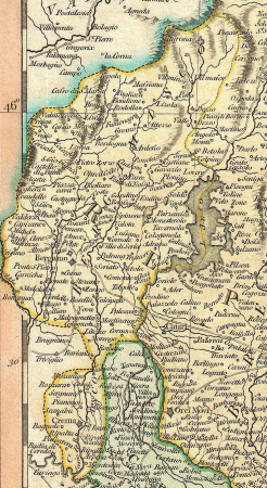
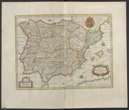
1660s maps of spain
1667 maps
encyclopédie méthodique - géographie physique
ambroise tardieu
maps of lichtenvoorde
house of bronckhorst
old maps of 's-hertogenbosch
empel en meerwijk
gemeente atlas van nederland - utrecht
maps of houten
atlas van der hagen (volume 3)
atlas van der hagen
maps of the duchy of limburg
1645 maps of belgium
maps of the history of the middle east
maps of 12th-century asia
maps of cambrai city walls
old maps of cambrai
1650s maps of china
1655 maps of asia
catalan atlas, 1959 reproduction
coats of arms on maps
1660s maps of spain
1667 maps
atlas maior, vol 11 (asia) - joan blaeu, 1667 - bl 114.h(star).11
1667 maps
1660s maps of spain
1667 maps
catalan atlas
mansa musa
grosser deutscher atlas
old maps of portugal
old maps of nijmegen
1664 maps
1501 - 1600 of 7,171
Next page
/ 72


![Titelblad] AFRICA](https://cdn.creazilla.com/illustrations/10000408184/titelblad-africa-sm.webp)


![[a] Bedfordiensis Comitatvs; [b] Bvckinghamiensis Comitatvs, Joan Blaeu, 1667](https://cdn.creazilla.com/illustrations/10001510670/a-bedfordiensis-comitatvs-b-bvckinghamiensis-comitatvs-joan-blaeu-1667-md.jpg)


